Sunday, September 29, 2013

Ride to Bagdad - Arizona

Every time we talk with motorcylists, they run through a list of places to ride in Arizona and ask us if we've been there. We probably haven't been there - yet. I count the places we've ridden in Arizona on one hand, and today thanks to the friendly and fun Prescott Star 511 touring group we added two more amazing locations to our list:  Skull Valley and Bagdad.


We met George who rides a BMW K1300S and Brad on a Yamaha FJR1300 at Starbucks and pulled out of the parking lot onto Iron Springs Road heading toward Skull Valley at about 9:30am. The sky was what I've started to call "Arizona blue", an intense bright, cloudless blue color that varies from a deep to a lighter hue depending on the angle of the sun.


I love learning about Arizona and the history behind the names of the towns and roads. Skull Valley, according to the Sharlot Hall Museum archives of the oral history project conducted by the WPA in the 1930's, was originally named by the Yavapai and Pima native Americans who fought a battle in this area. The dead were left unburied, which resulted in skulls and bones left in the valley for the white settlers to discover when they arrived in the mid-1800's.

I didn't see any skulls on our 15-mile ride down Iron Springs Road to Skull Valley (population around 743), but we did enjoy a large and spicy Mexican-inspired breakfast at the Skull Valley Diner.


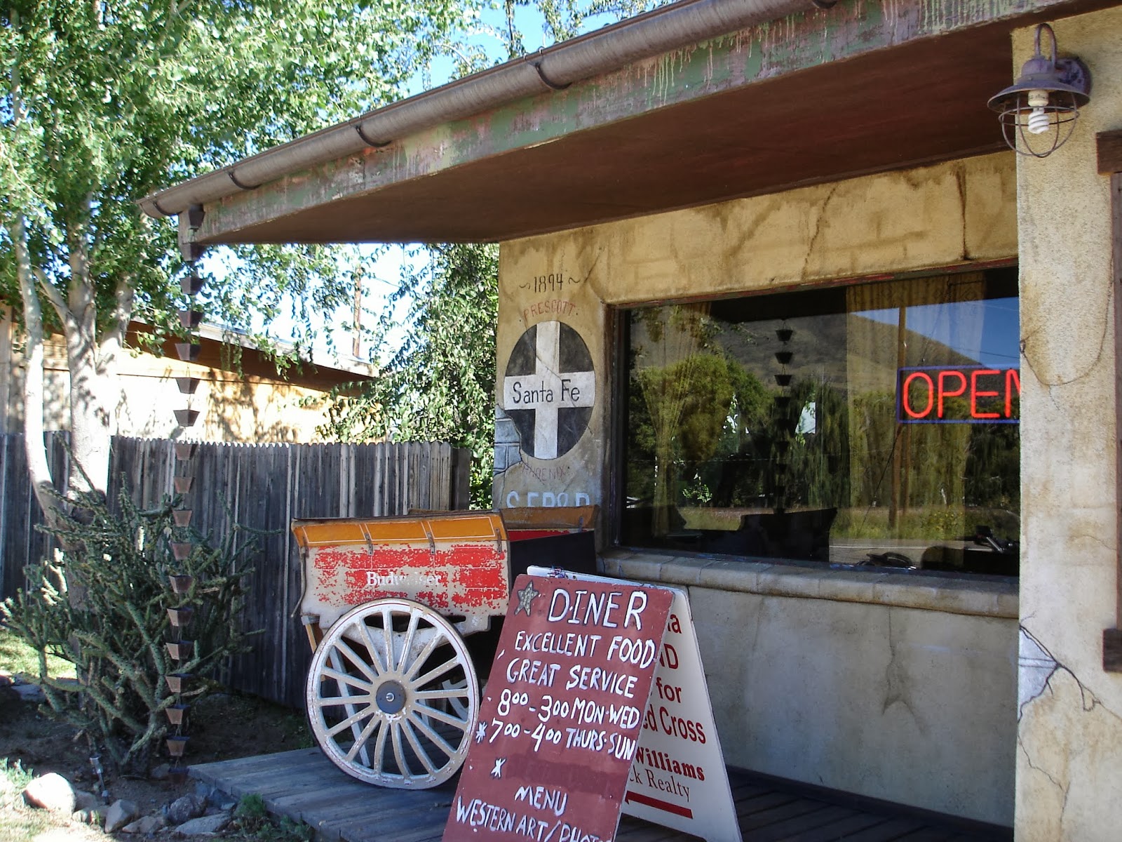
We sat outside in the warm sunshine and told stories about motorcycle travels that involved riding through the Alps, Badlands, and New England; and breaking down in the brutally hot Arizona summer.

I was glad for temperatures in the 70's as we continued to our next destination:  Bagdad, about 60 miles west of Prescott. Like so many Arizona towns, Bagdad was founded by miners looking for gold and silver. Today the townsite and the Bagdad copper/molybdenum mine are owned by Freeport-McMoRan Copper & Gold which continues its mining operations.


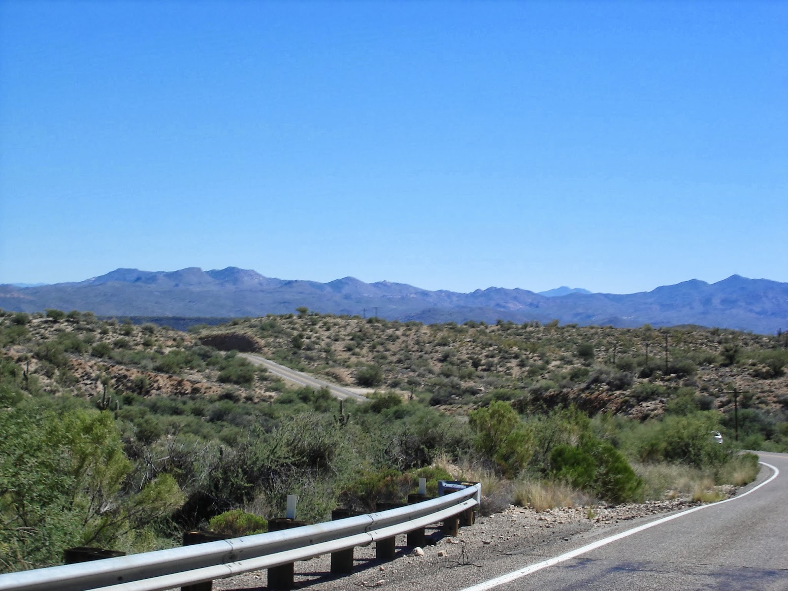
We climbed up and down through the rocky countryside, rarely seeing cars or motorcycles, or even houses. As we descended closer to Bagdad and the temperature climbed into the high 80's, I saw tall saguaro cactus covering the landscape. Saguaro are found primarily in the Sonoran desert, and Prescott is at too high elevation for this type of cactus.


The paved county road ends in Bagdad, where we stopped for an ice-cold drink (the bottle of water from the convenience store refrigerator actually had chunks of ice in it) before we headed back toward home.


palm trees in Bagdad, Arizona
Even though there's only one road in and out of Bagdad, everything looks a bit different going in the other direction. We ended our ride heading north on Route 89, riding through the Pondersa pines in the Prescott National Forest. This road is made for motorcycles, and we twisted our way through the hairpin turns and switchbacks, stopping a few times to look back at the pavement across the valley.


I want to go back to Skull Valley, stop in the train museum and eat another meal at the diner. Bagdad offers tours of the mine, and I'd like to explore some of the smaller roads that wind through the mountains north of Prescott. We've heard October is a beautiful month for motorcycle travel in the southwest, and we're ready to go.


Sunday, September 22, 2013

Windy ride to Payson, AZ

 
The first official day of Fall greeted us with a strong, cold northwest wind. On a motorcycle, a windy day takes on new meaning. Mike says the wind moves the bike sideways while we're going forward,  and we felt like bobbleheads during most of the trip.
 
Today Steve and Kim on their Kawasaki Concours and Tom and Christine on their Victory joined us for a ride to Payson on the Mogollon Rim.


Steve and Kim


Tom and Christine
 
Payson was founded in 1882 and became well-known in the early 1900's due to  books and movies about the area by Zane Grey. We were more interested in the limestone and sandstone cliffs that rim the valley, and the twisting roads that climb through Ponderosa pine forests.  


We like to ride through the changing countryside in northern Arizona, where in the space of an hour we travel through flat, dry high desert plains with mountain peaks a shadow in the distance; scrubby pines that dot the rolling hills, towering Ponderosa pines that crowd thickly together, dry creekbeds and washes, canyons that zigzag through the valleys; and steep, sharp rocky cliffs. Payson is only 100 miles mostly east and a bit south from Prescott, giving us plenty of time to stop for lunch at the Crosswinds Restaurant at the Payson airport.
 
The wind didn't let up during the ride back home, and the bright sun made the limestone cliffs stand out stark and clear against the clear blue sky.

 
I like riding in a group, stopping to talk and stretch our legs, chatting at a stoplight, and pointing out a passing helicopter as we ride down the highway. We have hundreds of miles of roads to explore, and I'm looking forward to future trips.
 
Mike and Lynn on the road - thanks for the photo Christine!


Wednesday, September 11, 2013

The Colorado Plateau on a rainy, cloudy day

The last day of a motorcycle trip has a different type of feel. We've been wearing the same clothes for several days, I've gotten used to minimalist living (which of my 2 shirts will I wear today?), I search out any fruit or vegetable that I can possibly find (fresh watermelon for breakfast at one hotel, oranges and apples in big bowls all day at another made me really happy), we've fallen into the rhythm of life on the bike (get up, eat breakfast, pack, ride through gorgeous countryside all day, stop every 2-3 hours for gas, food, water or just to stretch our legs; arrive at another hotel, unpack, go for a run, shower, eat dinner, sleep), and we're finally anxious to get back home.

We started the day in Blanding, Utah where the rain poured down all night long, and thankfully started to let up just as we headed out. Even with the rain, fog, and clouds that hovered below the tops of the craggy canyon peaks, this area of southeastern Utah is spectacular.


I kept imagining what this part of the country must have been like millions of years ago when volcanoes, inland seas, movement of the tectonic plates, and wind and river erosion began forming this high, dry desert canyonland known as the Colorado Plateau. The limestone and sandstone rocks and cliffs  have descriptive names such as arches, natural bridges, pinnacles, and monoliths.


Most of this area lies within the 27,000 square miles of the Navajo Nation, home to 173,000 people. That works out to about 6.5 people per square mile, which means the majority of the time we saw only the desert, rock formations, canyons and the sky. There's so little traffic we could stop on the narrow road shoulder to take pictures, or slow down to watch a solitary mule on a hill.


Our route took us south through Utah into Arizona toward Flagstaff, where we turned west on US 40 which mostly follows the route of the old Route 66. We can see the San Francisco Peaks from our home in Prescott, and today as they came into view we knew our trip was almost finished.


Minutes after we pulled into our garage, a hard rain started once again. Later that evening as the sun started to set we looked out the living room window to the San Francisco Peaks, now to our north.

Monday, September 9, 2013

Up and down the Colorado mountains

Think of Colorado and you probably imagine towering mountain peaks. I think about the sky:  brilliant bright blue on a sunny, cloudless day; menacing and dark with billowing thunderclouds; mist hanging down below the tops of the mountains on a rainy day, and a sun so blinding that even wearing sunglasses I need to cover my eyes to see clearly ahead of me.


early morning in Colorado Springs
 

The lowest elevation for the past four days was in Colorado Springs, 6,035' above sea level. It's amazing that even when we travel down into the valleys, we're still over one mile above sea level.

Today we rode west across Colorado into Utah, crossing the Rocky Mountains and winding through several steep canyons. We started off retracing our path from Friday, heading south on Colorado 115 and then west on US 50. Twisty Route 50 took us through the Arkansas Headwaters with craggy, rocky cliffs close to the edge of the road, ranches tucked into the hillsides, and miles of pine forests.

Arkansas River near Salida, CO
 
Sawatch Range


We barely had time to catch our breath before we crossed the Continental Divide on Monarch Pass. The temperature dipped down to the low 50's as we climbed to 11,312' and the clouds started to gather over the tops of the moountains.
 
Monarch Pass
 
We dropped down to around 7,000' on the western side of the Monarch Pass, into a high mesa valley that quickly became another winding, twisting road through the Curecanti National Recreation area. There are three reservoirs on the Gunnison River that stretch along the river canyon. We saw several fishermen and small boats as we rode 20  miles along the shores of the Blue Mesa Reservoir, created in the 1960's to provide hydroelectic power.


I could easily spend a week here, riding along the dirt roads the criss-cross the mountains, taking a boat road on the reservoir, and hiking on the miles of trails.
 
We were only half-way through the day but we had another amazing mountain road in front of us:  Colorado 145 which winds through the San Juan National Forest with several peaks over 14,000'.  Mike loved riding this highway with technical hairpin turns, long sweeping descents, and steep 7% grades. We passed by Telluride, originally home to silver mines and today a world-class ski area.


By the time we rode out of the San Juan mountains into the Great Sage Plains on the border between Colorado and Utah we thought the amazing scenery was behind us. We didn't count on the deep canyons that cross this high (over 6,000' elevation), dry area and the dark rain clouds that covered the entire sky.

 
There's little traffic and the small towns are spaced far apart in this remote corner of Colorado. We stopped at the Dove Creek Superette, which sells groceries, hardware, flowers, and hunting supplies for this town of around 700 people - and it's the largest town in the county.
 
We stopped for the night in Blanding, Utah which was originally settled by Mormans. I thought the name must be for one of the original town founders, but learned the town was originally called Grayson, and changed it's name in 1914 when a wealthy easterner offered a thousand-volume library to any town that would adopt his name. The town changed its name to Blanding, the maiden name of the easterner's wife and shared the prize with another town in Utah.
 
We missed most of the rain today as we rode west, and we're still smiling with the memories of the canyons, mountain peaks, and lakes. Tomorrow we head home, south through Utah into Arizona. It sounds like rain gear will be required.


Sunday, September 8, 2013

Pike's Peak or Bust

When the Colorado gold rush started in 1858, prospectors heading west painted 'Pike's Peak or Bust' on their covered wagons. We started the day by riding up the 19 mile paved road to the 14,115' summit of Pike's Peak, riding above the tree line on 'America's Mountain' that was first ascended in 1820.


Starting up the Pike's Peak highway at 8:30am was a good idea, because we had the road to ourselves and Mike could ride as fast as he wanted up and down the twisting hairpins. We stopped on our way down the mountain at mile 10, where Nate was racing in the Pike's Peak Downhill longboard race.


After watching the race, we headed west to Cripple Creek (elevation 9,454'), former gold mining town and current home to several casinos. The Band's "Up on Cripple Creek' song kept running through my head as we rode on sweepers and hairpin turns into the town.


We ended the day back in Colorado Springs, where we were surprised by bright sunshine and 90 degree temperature. It was cloudy and cool high up in the mountains, which seem to have their own weather system.

Tomorrow we start our two-day trip back home to Arizona, heading west across Colorado into Utah. We're hoping to miss the rain and thunderstorms that are in the weather forecast - keep your fingers crossed for us!

Friday, September 6, 2013

Colorado mountains

I always imagine Colorado as brown and rocky, but today's ride through several national forests and across pine-covered mountains was lush and green, especially compared to yesterday's ride through the dry desert-like high mesas.


on US 550 North toward Durango
 
We started off in Farmington, New Mexico and quickly crossed into Colorado, riding through the southern part of the San Juan National Forest, 1.8 million acres in southwestern Colorado. Pagosa Springs, elevation 7,000' and home to several hot mineral springs, is on the western side of the Continental Divide.
 

 riding east from Pagosa Springs
 
 
We crossed the Continental Divide on 10, 857' Wolf Creek Pass. We're riding through the Rocky Mountains that range from Canada to Mexico. Technically, Wolf Creek Pass is in the San Juan Mountain range with six peaks higher than 14,000'.
 

Wolf Creek Pass
 
The 1.8 million acre Rio Grande National Forest is on the eastern side of Wolf Creek Pass and the Continental Divide. We rode through the Forest on US 160, and stopped for lunch in Del Norte, originally a stage coach stop and a supply town for local mining operations.


I enjoy eating lunch in small, local restaurants to get a feel for the area. We were the only motorcycle riders among two men wearing cowboy hats, an elderly couple, and men dressed in casual business clothes. Del Norte is on the western edge of the San Luis Valley, a high altitude, desert-like basin that is heavily irrigated from underground aquifiers to support local farming. It's surprising to see dry, arid landscapes right next to bright green fields.


We rode on US 285 N through the San Luis Valley and then headed east on US 50  at Pancha Springs (elevation 7,465') and on through Salida (elevation 7,083').  The temperature today hovered near 90 degrees, even though we're at a high elevation. We stopped for a drink of water and talked with three guys heading out to ride motorcycles on the dirt forest roads that criss-cross the mountains.
 
 
We're staying in Colorado Springs (elevation 6,035') for three nights to watch our youngest son, Nate, compete in the Pike's Peak Downhill longboarding race. The lower elevation and miles of asphalt in Colorado Springs raised the temperature into the high 90's. The combination of heat and stop-and-go traffic made us glad to get off the bike and into an airconditioned hotel room.
 
We've covered almost 800 miles the past two days across three states, and we're looking forward to riding up the Pike's Peak highway tomorrow and looking down into the valley.


Thursday, September 5, 2013

Colorado bound

"I was standing on a corner in Winslow Arizona....." lyrics from the song by the Eagles kept running through my mind today. Our first stop on a 2-day trip to Colorado Springs was Winslow and as we rode northeast from Prescott I kept humming the classic Eagles' song.

We're headed to Colorado Springs to watch our son, Nate, race in the Pike's Peak Downhill longboard race this weekend. It's our first opportunity to ride the BMW on a multiday trip since we moved to Arizona one month ago. I'm amazed at the varied scenery on today's 415 mile trip:  up and down steep mountains, long sweepers through pine forests, brilliant green valleys bookended by high, dry mesas; mile after mile of sagebrush, deep and dry washes and creek beds, irrigated farmland, and terrain that we can best describe as 'moonscapes'.


After lunch in Winslow, we traveled on Route 87 north and Route 264 east first through the Hopi Reservation and then into the larger Navajo Nation, 27,000 square miles in Arizona, New Mexico and Utah. The road stretched out in front of us, and at one point Mike figured he could see 14 miles into the distance.


We saw preparations for the Navajo Nation Fair as we rode through Window Rock, and talked with a couple of people at the gas station about the hundreds who come into town for the fair, pow-wow, and rodeo competition.

Just east of Window Rock we crossed into New Mexico, the first time we've been in this state. We turned north onto Route 491, one of the Navajo Nation scenic roads known as the Trail of the Ancients because it winds through countryside first settled over 10,000 years ago.


We were surprised to cross canals filled with water and bright green fields of corn and hay as we rode closer to Farmington, NM our destination for the evening. The Navajo Agricultural Products Industry operates one of the largest farming operations in the country.


It felt jarring to ride down the 9% grade into the busy city of Farmington after spending the past 7 hours riding through countryside where we often didn't see a house for miles. At one point this morning a sign announced "no services for the next 51 miles" and at the end of the day we're in a city of 45,000.

Tomorrow we head north into Colorado and the Rockies, and I already have another song in my head:  Rocky Mountain High by John Denver.

Sunday, September 1, 2013

133 miles with cliff dwellings, red rocks, mining towns, mountains and a thunderstorm

Thank you Christine and Tom! Part of the fun of living in a new place is meeting people who share our love of riding a motorcycle, and today Christine and Tom were our tour guides on a 133 mile trip through the Verde Valley.


Arizona-blue skies with puffy white clouds and the temperature hovering around 90 made for a wonderful day on the BMW. Our first destination was Montezuma Castle National Monument, 50 miles and 1000 years from Prescott.


The southern Sinagua farmers built this 5-story, 20-room dwelling sometime between 1100 and 1300 on cliffs that rise 100 feet above the valley. It's amazing to think about the amount of work that went into simply staying alive:  carrying water and food from the valley up a series of wooden ladders into the village built into the side of the limestone cliffs.

From Montezuma Castle we headed northwest to Sedona and the gorgeous sandstone red rock formations. 

Unfortunately, it seemed like everyone in the state of Arizona had the same idea as bumper-to-bumper traffic backed up 5 miles outside of Sedona. Instead of melting in the 90 degree sunshine and heat reflected off the asphalt, we took a quick left and headed west toward Cottonwood, known for its historic downtown.

We all were glad to leave the traffic behind us as we traveled on almost-empty, twisty roads through Cornville and Page Springs.


According to the Cottonwood website, “In 1874 soldiers from Camp Verde were stationed at an adobe house, but at that time there was no name for the present Cottonwood (where the house existed). As settlers moved in and the community developed, it took its name from a circle of sixteen large cottonwoods growing about one-quarter of a miles away from the Verde River. The place was unhealthful. Malaria and dysentry were severe problems as mosquitos rose in thick clouds from stagnant pools left by receding floods."

We didn't see any stagnant pools or mosquitos, but I did spot two hang-gliders. We stopped for lunch at Old Town Cooperage on the old historic main street in Cottonwood before continuing south toward Jerome.


Jerome barely hangs onto the side of the mountains where it was founded by miners, grew to 15,000 people working in the copper mining industry in the 1920's, survived 4 large fires that destroyed much of the downtown area, and currently is a busy tourist town promoting its history, arts and crafts, and numerous local wineries.


We tolerated the traffic in town in order to have fun on the hairpin turns and winding, twisting road that leads south from Jerome toward Prescott. This route was made for mules and wagons but today is great fun on a motorcycle. We even saw one person riding a longboard, reminding us of our son Nate who races longboards.


The sky seems to go on forever in Arizona, and as we headed toward home we could see dark clouds unleashing sheets of rain to the north and south. At one point we saw a 'window' of bright blue sky, book-ended on each side by black clouds and heavy rains.


Imagine standing in the middle of that 'window', watching the rain pour down all around. Even though we saw lightning in the distance we felt only a few sprinkles as we rode back into Prescott. We ended the day sitting on the porch at Christine and Tom's house, talking about the ride, watching lightning, and finally spotting a rainbow.

We're already planning the next ride!